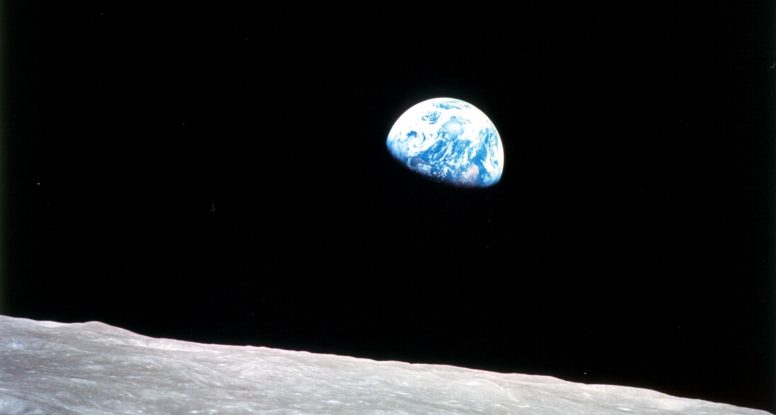
How ‘BOUT that Earth!
When Apollo astronauts first visited the moon, they brought back something somewhat expected (though predicted by Heinlein in Rocketship Gallieo) a gorgeous view of our little “blue marble” poised all alone in space.
Nothing will ever match the poignancy of that image, but as technology has improved, we’ve given it some competition.
This image, was used as wallpaper on the Apple iPhone until 2012:
But this is not a photograph of Earth. At all.
At the time this image was created in the early 2000a, all of NASA’s Earth-observing satellites were either in low Earth orbit or Geosynchronous orbit, and none were capable of capturing a truly full view of the entire disk of the Earth in high definition color. To get such an image in one shot, you’d have had to go back to the film photographs taken during the Apollo Program.
Robert Simmon, a data visualization expert at NASA’s Earth Observatory, created the image above from four months of light data from NASA’s Terra satellite (launched in 1999). The photo-composite was stitched together from 2,300 km (1,429 mi) wide bands captured as Terra orbited from pole to pole and Earth rotated beneath it. These were digitally applied to a virtual sphere, then cleaned up in Photoshop. The atmosphere is not visible at this scale, and was added using digital blur. Some of the clouds are collaged together using Photoshop’s clone tool to cover gaps in the satellite’s coverage. The background is just black pixels.
It is not a photograph, and was never intended to be. It’s a visualization of data from the Terra satellite.
If you want a proper, full disk image of Earth, I favor this one by the LRO, captured from orbit around the moon in 2017:
But this is a composite too. Spacecraft are mostly designed to do science and survey work, not to take pretty pictures.
But today, with improving technology, there are several satellites that routinely image the entire disk of the earth in high resolution.
DSCOVR, orbiting the sun a million miles from Earth away in the Earth-moon Lagrange 1 point may have the images most similar to Simmon’s composite, though its EPIC camera is a scientific instrument, and is often the case with space imagery, “natural color” images must be made in the computer by adjusting the sensor bands closest in sensitivity to the human retina.
See it here: USA: DSCOVR (L1)
Similarly, Goes-16 full disk images are composites drawn from the 16 spectral channels of its imaging camera. Operating from geosynchronous orbit, it is however able to render single images of the full disk in high resolution, and these images are available live on the web, with controls to permit zooming. You can, for example, see how the terminator widens and smears toward the poles. It’s pretty cool: GOES 16 (RAMMB/CIRA SLIDER) (Zoomable, HD) , NEXLAB, NOAA Full Resolution
Japan’s Himawari-8 is functionally similar to GEOS-16 (at least for our lay purposes) and used for the same purpose (weather monitoring) but flies over the Pacific and Japan. Like GEOS, its camera has 16 sensors with difference spectral sensitivities, three of which are fairly similar to humans’. You can see its spectacular imagery here: Himawari-8 Real-time Web – NICT
And there are more…have fun:
- Europe: Meteosat-10 (11K), Historical Viewer (slow)
- India: INSAT
- Russia: Elektro-L (11K) (Ntsomz interactive view and download) (FTP Archive)
- USA: GOES-West & GOES-East. (Raw West, Raw East)
